


Archeogeophysics
Lately, all recognize that the excavations are inherently destructive and irreversible harm the environment and often the monuments. Performance of prior non-destructive research is gaining ground as a mandatory stage in archaeological research.
Through geophysical methods produce 2D maps and cuts, 2D sections and 3D models of objects in non-destructive way. So thanks to complex geophysical studies before we shovel stuck, we know what awaits us.
In addition to the savings achieved to the greatest possible accuracy in determining the perspective areas and optimize the revealing staff
| March 2013, we were again invited to perform georadar survey of Thracian tomb. The main task of this study was to locate archaeological complex structures with size 15.6 acres, including mound and the area around it. The study was conducted in two phases - field measurements and tracer and cameral processing and interpretation of results. The animation and the final study outcome can see the video on the left. |
|
| After many good reviews, the company was awarded a georadar survey of the old town of Sozopol. Georadar survey was designed to clarify the location of the southern fortification system of the city. The results clearly delineated the presence of massive structures, columns and arches, which archaeologists suspect that a central entrance to the city. The information provided can be an introduction toReport Sozopol. Georadar Additional studies revealed the presence of coffin burial in the church "St. Nicholas." The sarcophagus was excavated and found its contents. |
|
| October 2012., The company was commissioned to make georadar survey for the presence of underground archaeological structures around the existing monastery. Surveyed areas were divided into two - north (survey zone 1) and internal (investigation zone 2). Processing and interpretation of the results showed the presence of archaeological structures. The data were confirmed by the archaeologist on site. Information obtained from the study can be found inReport monastery. Note. Location data of the study were deliberately obscured. |
|
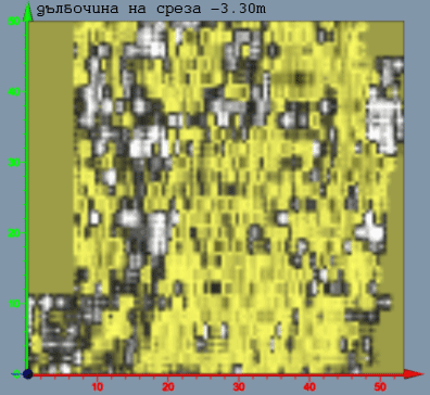 |
Animated picture (left), are displayed in a series of horizontal sections of the site measuring 50 to 50 meters. The data are processed in REFLEX 3D. Interpretation of the results provides insight aggregating archaeological objects displayed in white. |
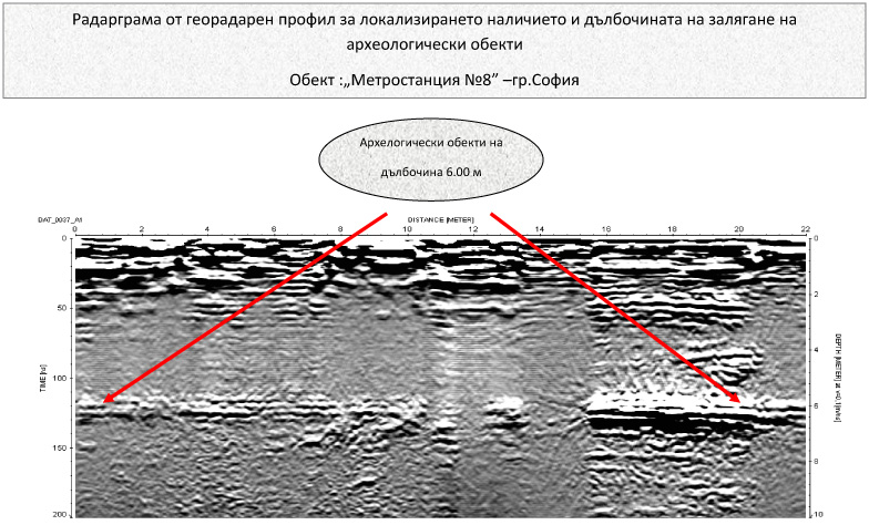 |
In excavating the subway, is suggestive of archaeological sites. The company was commissioned to make the square georadar survey. Committed georadar survey, found archaeological structures. On radargram (left) shows the methodology for determining the depth architecture. |
 |
|
